2015 Nova Scotia, Canada Blog
Today, 8/24/2015, we are on our way from Auburn, Maine to Nova Scotia with stops in New Brunswick and also Prince Edward Island. It should take us most of the day to get to Moncton, New Brunswick.
Leaving Auburn, Maine, we traveled north on I-95 until we
reached Orono, home of the University of Maine Black Bears, and then on route 9. We headed
east on route 9 until reaching route 1 and turned south to Calais and our
gateway into Canada via St Stephen.
Our goal for the first day in Canada is Moncton, New
Brunswick. The plan is to drive east on Trans-Canada's
route 1 and spend the night in Moncton then visit Hopewell Cape for the Bay of
Fundy tides. From there we'll drive to
Prince Edward Island for our next night.
The next morning, 8/25/2015 - day 2 of our trip, we were
going to go straight to the Hopewell Cape to see the Hopewell Rocks and walk
along the sea floor. However, we decided
to travel along the Fundy Trail in a clockwise route (east on route 114), so we
head west on TC-1 to exit 211 for route 114 east. Our first stop is in Fundy National Park near
Alma.
At Alma, we turn south on Point Wolfe Rd. The weather is a little overcast and foggy,
but we still have some great views of the coast (seen above). A couple of Adirondack chairs to rest and
look out over the ocean.
The falls, about 20 feet high, cascade into a flume with
smaller falls and follow a walkway along the stream.
A closer view of the Falls from the stairs and deck next to the water falls. The trail continued for another 3/4 miles, if you turned left. But, we turned right and headed back to the parking lot to get back on the road.
From the bridge, looking downstream towards the ocean, you
can see the dramatic view that would have been seen from the saw mill.
Just after Alma, we jump onto RT-915 and head to Cape Enrage
and the lighthouse. Waterside beach,
though a beach, has no sand, just flat rocks.
People have been stacking the rocks to form cairns on the
beach. You can see the other side of the
cove along with this stack of stones.
Next we come to Cape Enrage lighthouse, on the cliff, just
further along the road where from Waterside beach.
Our last stop along the Fundy Trail is at Hopewell Cape
where the Hopewell Rocks are located.
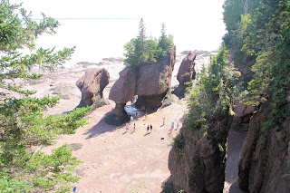
Seen from the platform before descending the stairs, it is easy to see why these formations are
called the "Flower Pot Rocks".
The tide is out and between high and low tides, after paying
the park fee, you can walk down to the base of the rocks and walk where the
water was at high tide. Here you can see a number of people walking among the rocks.
You can clearly see the tide water wear and the people
standing below the rocks. The tide, when
in, is up to the top of the worn areas almost 40 feet above the ground.
From the sea floor on the south end of Hopewell Rocks.
Here you can clearly see the viewing platform in the upper center of the picture and the staircase we used to get down to the bottom.
Here you can clearly see the viewing platform in the upper center of the picture and the staircase we used to get down to the bottom.
More views from the sea floor.
It was so interesting that I could not stop taking pictures. As you can see, here is another view of the rocks and coast, now above water.
Here you can see Carmen on the second landing of the staircase.
As we begin to leave, we get our last view of the Hopewell Rocks, again from the viewing platform. We stayed on the "sea floor" exploring for about an hour and a half. but we need to leave and the tide will still not be high for several more hours.
Back on the road, we are now headed to our next overnight
stop, which will be in Charlottetown, on Prince Edward Island. To get there we cross over the Confederation
Bridge, connecting New Brunswick and PEI.
While on PEI, we made a couple of stops along the coast. One of those stops we were able to get a picture of a rainbow.
Driving through PEI, we have seen potato, corn and wheat
fields. But, we also saw fields which
had yellow flowers. Not sure what the
plant was, but it was pretty. Carmen was
able to get a picture while I was driving.
Just as it started to sprinkle and before the harder rain, I
ran out to one of the red sand beaches to get a picture. So now we have been to white, red, black and
green sand beaches.
Our next stop is our hotel for the night, so we'll see you
tomorrow.


No comments:
Post a Comment